


 |
| Pulley wheels in the Cong Burn, 80' below the Waldridge Waggonway (photo courtesy of Tom Hartley) |
 |
| A wire hauler rope in the undergrowth alongside the Waldridge Waggonway (photo courtesy of Tom Hartley) |
 |
| The rope close up (photo courtesy of Tom Hartley) |
 |
| Waldridge A pit (bottom of map) had Margaret (AB 1005 of 1904), built alongside Horden by Barclays, which had many orders from NE England around 1900 |
Tom's Waldridge Incline (highlighted in purple on the map below) is on the waggonway route from Stella Gill sidings (near top right of map) past Waldridge D & A pits to Sacriston:
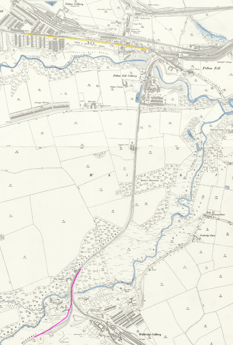 |
| Tom was where the Waldridge Waggonway Incline (purple) runs alongside the Cong Burn (blue) (OS Map segment c 1890 courtesy of the National Library of Scotland) |
The other Waldridge Incline is shown in yellow on the map. This is on the alignment of the Stanhope & Tyne Railroad, which went bankrupt in the 1830s to be resurrected as the Pontop & South Shields Railway. There were 4 inclines (Waldridge, Eden Hill, Twizell, Stanley) in succession between Stella Gill & Stanley, so the NER built the Annfield Plain Branch as a bypass (part shown at map top right), later used by Tyne Dock - Consett iron ore trains.
 |
| Looking down from the head of Waldridge Incline (S&TR) Note the rope down to the empty set on the right; the open catch point on the left, behind which fulls will be standing with the rope attached at their rear; the meetings in the distance, half way down the incline |
 |
| In 1968, Twizell stands in steam at Stella Gill yard (empty due to pit closures), having descended the S&TR Waldridge Incline en route from Handenhold to Morrison Busty - so it's waiting for a pilot before heading up the Annfield Plain deviation curving away to the right |
Further reading:
Chester le Street Heritage web has interesting coverage of Waldridge A & Waldridge D pits.
(Tom's) Waldridge Waggonway is covered in a Wordpress blog.
There is an excellent web site covering Stella Gill / South Pelaw Junction.
Rob Knox found a very useful interactive map of the area.
PS It would have been helpful if the S&TR Waldridge Incline was named Newfield or Pelton, because it isn't as near to Waldridge as that heading to Sacriston. I found the clue to there being two Waldridge Inclines in Rope & Chain Haulage, CE Mountford, IRS 2013.
3 comments:
A very interesting piece of very local Industrial Archaeology - supported by maps. Thanks!
I grew up playing in these woods and there are lots railway Archaeology around when you look. I have a Fish plate and Rail chair in my garage found around that area.
Further up the burn there is a waggon wheel on the bank.
Official report on an accident.
https://www.railwaysarchive.co.uk/documents/BoT_Waldridge1893.pdf
Post a Comment